North Dakota State University: Agricultural and Biosystems Engineering Dept.

My photo
Our project titled the "Effect of Optimal Water Management for Sustainable and Profitable Crop Production and Improvement of Water Quality in Red River Valley" is funded through the Sustainable Agricultural Research & Education (SARE) grant.

Wednesday, October 9, 2013

Harvest [2013]

The farmers are harvesting their crops, which means that our team has been spending a lot of time out in the field moving and re-positioning sensors and observation wells as well as collecting yield data.

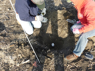
Below is a picture of a few of our team members, Dr. Xinhua Jia, Dr. Dongqing Lin, and Debjit Roy (doctoral student), walking in the soon to be harvested soybean field.  On this day the task was to lower our water table observation wells about a foot below ground so that they were not damaged during harvest.

Left to right Dr. Lin, Dr. Jia, Debjit Roy in the soybean field before harvest.

Burying of water table observation wells.

In addition to moving and re-positioning our equipment/sensors our team has also been collecting yield information by looking at the yield from various 10 ft. x two row wide sections at each plot.

Currently, we are waiting for the corn fields to be harvested, but in the meantime we are processing and analyzing this years data!

Monday, September 23, 2013

SARE Field Tour 9/13/2013

The SARE field tour consisted of about 40 attendees, some of which included Larry Luick (ND state senator), local farmers, representatives from local agencies (State Water Commission, NRCS, etc.), and representatives from nearby companies (Houston Engineering, Ellingson Companies, etc.).

The start of the day consisted of a brief overview of the project on North Dakota State University (NDSU) campus and then turned toward visiting the research site out in Moorhead, MN.
Dr. Tom Scherer talking about the SARE project
At the research site attendees where brought to both the drainage outlet and subirrigaiton sites (shown below).
Drainage outlet - consists of three controlled drainage structures which help  monitor three individual sections of the farm plot.
Gerry Zimmerman (the farmer) describes his setup of the three controlled drainage structures.
Dr. Xinhua Jia describing the subirrigation system located on the opposite side of the county drainage ditch.
After visiting the research site attendees were brought back to NDSU for some organized group discussion which consisted of three groups, each with a different question (i.e. each group talked about a different issue associated with tile drainage and water management).

Blue group - Kelsey (M.S. student) took notes

Red group - Debjit (Doctorate student) took notes

Green group - Kyle (M.S. student) took notes
After the group discussions summaries were made by each group and shared with the entire room.
Red group summaries

Blue group summaries

Green group summaries
After the group summaries additional discussion occurred, questions were taken, and the day came to an end!


Tuesday, August 20, 2013

Drained vs. Undrained fields

Thus far we have talked quite a bit about our subirrigated corn fields, but we also have two soybean fields (one that is subsurface drained and one that is undrained) which have provided some interesting comparisons between drained and undrained fields.

Some key points to note about the two soybean fields are:
  • Similar soil series amongst two fields
  • Same preceding crop (corn)
  • Same variety of soybean is grown in both fields
  • Relatively same location (two fields are about 1/2 mile apart)
Even though we are still in the process of collecting/analyzing data we can still visually see differences between the subsurface drained and undrained fields.  Below are pictures of the undrained and subsurface drained fields.

Undrained soybean field.  Water logged soils at the beginning of the growing season may have been a contributor to the stunted growth/development of the crop
Subsurface drained soybean field.
 
 
A person can easily see, from the photos, that the subsurface drained crop (bottom photo) is much taller/fuller than the undrained crop (top photo).  Hence, supporting the use of subsurface drainage in the Red River Valley.

Monday, August 12, 2013

Subirrigation

The subirrigation system has been running for almost two weeks and our team is busy attaching various sensors to help estimate irrigation amounts/efficiencies.  The subirrigation system uses the pressure head created in the tank to push the subirrigation water uphill, in the main, and then uses the downhill gradient of the laterals to move the water by gravity.  Below are a couple pictures of the subirrigation system.

Subirrigation system.  Far right- control box, center-tank, left- manifold.

Subirrigation manifold.   The two white PVC lines supply water to two individual sections at the research site.


Thus far, a variable rate current sensor, time-logged cameras, and flow meters (attached to the manifold and individual PVC) have allowed us to better determine when the irrigation system is running, the amount of water being delivered to the system, and the amount of water being delivered to each section of the field.

Below is a picture of a graduate student, Kyle H., preparing a section of PVC, with a pre-attached flow meter, so that we can better estimate the amount of water delivered to a specific section of the field.

Tuesday, July 30, 2013

ASABE 2013 Annual International Meeting

The 2013 ASABE Annual International Meeting was held July 22-24th.  Here Kelsey presented her poster titled:
Using Eddy Covariance, Soil Water Balance, and Photosynthetically Active Radiation Methods for Corn Evapotranspiration Measurements in the Red River Valley
 
And Kyle presented his poster titled:
 
Methods, Techniques, and Considerations for Subirrigation Practices in the Red River Valley of the North


In addition to presenting at the ASABE Soil & Water poster session, Kelsey and Kyle each wrote a paper (available online to ASABE members) which covers, in depth, the keypoints of their poster.


Monday, July 1, 2013

Rain Rain...go away!

So far it has been a WET spring in the Red River Valley! 

Our most recent storm, on Tuesday June 25th, produced about 2.91'' of rain!  This resulted in ponded/water logged soils at our undrained plot, see pictures below.
Southwest corner of the undrained field

West edge of the undrained field
The wet spring has also put the landowners subsurface and controlled drainage systems into use.  Below is a picture taken, at our free drained plot, of the subsurface drain tile outlet (left) and surface runoff culvert (right).
Drain tile outlets for subsurface drainage (left) and surface drainage (right) at the free drained site
 
Similarly, the subsurface drainage system was being put to use at the control drained and subirrigated plots.  Below is a picture of the drain tile outlet, which is at the same level as the ditch water level due to flash flooding from the previous storm.
Subsurface drain tile outlet for the control drained and subirrigated sites
 
However, amongst all of the rain and wet field conditions, we have managed to collect soil samples and water table data from the 24 wells placed throughout the undrained, free drained, control drained, and subirrigated fields.  The soil samples help us to calibrate our soil moisture sensors and the water table data helps us to visualize what is happening beneath the ground so that we can better understand water balance and crop stressors.  For example, after our last big rain on June 25th the water table rose 1.5 ft in some areas which resulted in water logged soils in the undrained field and drainage in the subsurface drained fields. 


Tuesday, June 11, 2013

Busy Bee's in the SPRING!

It's been a busy spring and everything is ready to go!

Thus far our major field activities have included:

1) The setup and installation of our Eddy Covariance system in a NEW location at the research site because the farmer is now irrigating the center of the field and using control drainage on the southern portion.

 
2)The setup of all three wireless weather stations located in the undrained (UD), free drained (FD), and subirrigated (SI) fields.
This is a picture of the SI wireless weather station with Eddy Covariance in the background.  On this weather station there is a photosynthetically active radiation, rain, soil moisture/temperature, and relative humidity/temperature sensor.  The other two wireless weather stations in the UD and FD fields have similar sensors with the addition of wind sensors which measure wind gust, direction, and speed. In this picture the relative humidity and temperature sensor is being lowered to 1.0-1.5m above the crop canopy. 

3)The lowering and raising of the 24 piezometers (screened wells) located through out the research site due to the farmer tilling and planting his field.  The wells must be lowered a foot or more beneath the ground surface so that the farmer does not damage the equipment while he tills and plants the field.  Then once the field is tilled and planted we can raise the piezometers and launch the HOBO water level transducers, placed inside the wells, which help us monitor the ground water level throughout the field.


4)Installation of turbidity and water level sensors at two locations in the county drainage ditch.  One set is located kitty corner of the FD field and the other is located at the north western point of the SI and CD field.  By doing this we are able to monitor water quality in the ditch before and soon after subsurface drainage has entered.

Sadly, however, due to a fair amount of rain over the past couple of weeks the water level in the ditch raised above the sensors and either destroyed or damaged most of the sensors and data loggers.  They are in the process of being repaired or replaced, and are expected to be back up and running within the next week or so.


5)Installation of a Stingray Ultra Sonic Flow Meter, which monitors water level, velocity, and temperature of flow in a pipe or channel.  This sensor is located in the Free Drainage (FD) tile outlet, and will allow us to quantify the volume and timing of drainage events from the FD field.


6)Installation of weirs and water level sensors at drainage outlets for the CD, SI, and FD fields.  Again, we hope to estimate the surface runoff from these fields by making use of v-notch weirs and HOBO transducers, which monitor water level every 10 minutes.


This has been an exciting and BUSY spring, but now it's time to get to the fun part and put our sensors/equipment to work as the growing season begins!


Sunday, April 7, 2013

Hey!

So it's time to start getting back out into the field! 

In March we
  • Continued to collect and process data from our wireless weather stations and Eddy Covariance systems. 

  • Visited our "free drained" field to re-launch/re-start a malfunctioning weather station

  • Visited each of our 24 wells (located in our undrained, control drained, and subirrigated field plots) to ensure that our HOBO water level loggers were working and the wells were functional.
Below is the link to a video which briefly summarizes our Eddy Covariance and wireless weather stations along with providing a look at the research site during the winter months.


Monday, February 18, 2013

So far in the New Year we have...

  • Switched our cellular transmitters for satellite transmitters on our weather stations.  These transmitters allow us to view our data in "real time". By this we mean that we can look at the data our weather stations are collecting (soil temperature, soil moisture, wind speed/direction, relative humidity, air temperature, photosynthetic active radiation, etc.) every couple hours through the DataGarrison site online.

  • Looked at wind sensor problems (wind gust/speed) caused by the freezing rain/snow and looked at different options to resolve this problem (i.e. calling Onset technical support, asking around the department, etc.)

  • Gave a representative (Alisha) from the college of agriculture, here at NDSU, a tour of our North Moorhead research site

  • Continually processed wireless weather station data to check that sensors are working correctly

Thursday, February 14, 2013

Project Summary


ABSTRACT:

Following a wet weather pattern since 1993 in the Red River Valley (RRV), located in eastern North Dakota and northwestern Minnesota, excess moisture in the farmland has become the most limiting factor for crop production.  Subsurface drainage (SSD), a new technology for the RRV, has become a necessary and effective way to remove water, lower the water table and reduce soil salinity.  Due to concerns on water quality, especially nitrate losses from the SSD flow, controlled drainage (CD) can be used to reduce the total amount of drainage water and nitrate moving out of the field.  Subirrigation (SI), which adds water to the field during high water demand period, can increase crop yield.  In addition, the SI will use the ditch water next to the field as the waster source so that the phosphorous and sediment load in the surface water can be decreased through the field filtration process.  The dual CD and SI system is new to the RRV region, the design used in this project is suitable for the flat topography of the RRV region, and the day to day water management protocol is innovative and has not been studied before.  Field experiment with four treatments, undrained (UD), free drainage, CD, and CD+SI, will be conducted at Clay County, MN.  Water balance components, such as rainfall, irrigation, evapotranspiration, drainage, surface runoff, and soil moisture changes will be measured.  Water quality will be monitored at upper and downstream of the ditch.  Sugar beet, corn, and soybean yields will also be estimated for each growing season.  During the project duration, field days, workshops, and evaluation will be conducted annually to demonstrate the project progress.  It is expected that more people will be able to use CD and SI following the success of this project. 


Below is an aeriel view of the research site located in Clay County, MN.